Tunisian Shipping Ports
PORT OF BIZERTE / MENZEL BOURGUIBA
The port of Bizerte is dominated by oil traffic.
Geographical location:
Position : 37° 16′ N – 9° 53’E
Infrastructure
Basins
- Outer harbor: 52 ha, at -13 meters (Marina: 34 ha).
- PCanal port: 28.8 ha, at -12 meters.
- BSebra Bay : 46 ha, at - 10 meters.
Berths :
- Banal berths / 5 berth trading quay - length: 523 m, draft: for berth 1 is -9.30 m and berths 2, 3 and 4, it is -09.65m and berth 5 is a draft of -9.80m
- Specialized oil tanker stations A / B: respective lengths: 250m / 150m –and draft respectively -10.67m / -7.80m.
- Cereal quay length: 200 m and with a draft: -9.75 m.
- Sugar quay length: 168 m and with a draft: -10 m.
- Tunis-Steel substation: length 120 m - draft: - 9.00 m.
- Cement station: length: 174 m - draft: -9.00 m.
- OXY quay: length: 16 m - draft: -5.5 m,
- Easement quay (for docking tugs): length: 120 m - draft: -5.5 m.
The commercial port of Bizerte offers a total linear of quays with a length equal to 1721 m.
PORT OF LA GOULETTE
The port of La Goulette specializes in receiving passenger ships and cruise passengers. It also receives ships carrying: cars, trailers and rolling vehicles.
Geographical location :
Position : 36° 47′ N – 10° 16′ E
Infrastructure
Basins
- The main basin: 63.6 hectares, dredged at -11.5 meters (channel inside the basin) and includes a turning circle 370 meters in diameter dredged at -12 meters and built downstream of the entrance pass port.
Berths :
These works are as follows :
- Commerce quay (North) post (1) with return (1a) with a length equal to 146 m, and a draft of -8.2 m and -5.1 m respectively.
- The quai de Commerce (North) berths (2, 3, 4, and 5) with a length equal to 584 m, and a draft of -8.2m for post number 2, and -8.8m for 3, 4, and 5.
- The Commerce quay (North) post (6) car-ferries + conventional ships with a length equal to 180 m and a draft of - 8.8m.
- Quay (7) car ferries 180 m in length, and a draft of - 8.8m.
- The commercial port of La Goulette offers a linear quay with a total length equal to 1090 ml.
- A floating platform “Didon” 40m / 30m and offering the possibility of simultaneous berthing of two passenger ships or Ro-Ro ships.
Cruise terminal :
- 2 berths specialized exclusively for handling cruise ships over a length of 657 ml, and a draft of -9 m and - 8.8 m.
Maritime Station :
- The commercial port of La Goulette has at its northern end a ferry terminal for travelers located at the front of the Port in front of the berth n ° 7 which is served by a platform and an access ramp allowing berthing and handling of motorized passenger ships (car ferries) .This terminal is made up of:
- Three stations with a floor area of 6.5ha and a car capacity of 1600 cars.
- A passenger room for handling pedestrian passengers with an area of 5000 m².
- 04 berths served by a floating platform making it possible to accommodate two vessels simultaneously and to handle Ro-Ro Pax type vessels.
- 02 mobile telescopic gangways on rails to ensure the passage of pedestrians between the ship and the reception area
PORT OF RADES
Ro-ro port, the port of Rades handles the majority of the country's container and wheeled unit traffic as well as part of the bulk traffic (hydrocarbons, cereals).
Geographical location :
The port of Radès is at 36 ° 40 ′ latitude and 10 ° 10 ′ longitude. It is the geographical extension of the port of La Goulette.
Infrastructure :
Basins
- The terminal basin: the water body of the terminal basin has an area of 80 ha dredged at -10.50 meters and a turning circle 430 meters in diameter.
- A turning circle of 370 meters in diameter (Goulette basin) located at the height of the specialized berths on the south shore.
Berths :
Main basin (container and ro-ro terminal): :- Container ship 2 berths (1 and 6) - length: 350 ml - and a draft of -8.8 m.
- Ro-Ro / 4 berths (2, 3, 4, 5) - length: 600 ml / (4 x150) and a draft of -8.80 m and -8.00 m for berth number 5.
- Container ship / Ro-Ro 1 mixed berth (7) - length: 180 and a draft of -9 m. The main basin offers a linear with a total length equal to 1130 m.
- Quai Céréalier (behind this post, a 30,000 T grain silo) length: 109 m and a draft of - 9.75 m.
- Oil / Gas quay (ordinary post) - length: 130 and a draft of -9.45m.
- Multi bulk dock (ex KD) - length: 200 m - and a draft of -10.5 m for liquid and solid bulk goods.
- Industrial products wharf - length: 58 m - and a draft of - 7.2 m - for general goods.
- Bulk liquid quay - total length between the Dukes of Alba: 53 m and a draft of -8.00 m to the right of the main line.
Protection works
- The water level of the port of Radès is sheltered by the protective structures of the port of La Goulette.
Stores and full grounds
- The customs area of the container and ro-ro terminal assigned to the deposit of goods in transit covers an area of 50 ha: 2 ha covered by 4 hangars and 48 ha of land.
PORT OF SOUSSE
The port of Sousse mainly handles general cargo.
Geographical location :
The port of Sousse is located on the eastern coast of the country.
Position : 35° 49 N – 10° 39 E
It is made up of two independent zones (north shore and south shore).
Infrastructure
Basins
- Principal : 21 ha.
- Fishing : 1,8 ha.
- Sailboats : 1,7 ha.
- Turning circle: 300 meters in diameter.
Berths
- Post n ° 1 (West) 125 m long with a depth of - 8.50 m Hydro.
- Trade quay (North): berths (2, 3, 4) with a total length equal to 307 m with a depth of - 8.50 m.
- Station n ° 5 175 m long with a depth of - 8.50 m.
- Post n ° 7 (South Shore) 220 m long with a depth of - 8.20 m. this station has a 30m return which is available for Ro-Ro vessels.
- Station 6 170m long for loading salt equipped with 3 Alba dukes and with a depth of - 8.50 m.
Protection works
- A North pier 510 m long.
- A north groyne 185 m long and 68 m wide allows the blades to stop.
- A southern groyne 340 m long and 50 m wide.
- The port access pass is 65 meters wide.
PORT OF SFAX
The port of Sfax is a multipurpose port. Its dominant traffic consists of solid bulk (phosphate and derivatives, sulfur, sea salt, cereals, etc.) as well as containers.
Geographical location:
Position : 34° 43′ N ; 10° 46′ E
Infrastructure
Basins
- A main basin with an area of 42 ha.
- A basin (NPK) with an area of 15.5 ha.
- 1 basin (sailboats) with an area of 4.5 ha (easement).
- Turning circle: 300 m in diameter.
Berths :
The berthing structures consist of 15 berths distributed as follows:
- NPK quay (station n ° 1) of total length equal to 150 m with a depth of - 10.50 m Hydro.
- NPK quay (station n ° 1) of total length equal to 150 m with a depth of - 10.50 m Hydro.
- NPK quay (station n ° 1) of total length equal to 150 m with a depth of - 10.50 m Hydro
- Quai des phosphates (station n ° 4.5 and 6) 584 ml long with a depth of -10.50 m
- Commercial quay (station n ° 7,8 and 9) 520 ml long with a depth of -10.50 m
- Easement wharf (station n ° 10) 60 m long with a depth of -10.50 m
- RORO wharf (station n ° 11) 150 m long with a depth of -10.50 m
- Trade wharf (stations n ° 12, 13 and 14) long. 517 m with a depth of -10.50 m
- Quai des salines (station n ° 15) 110 m long with a depth of -10.50 m
- 150 ml long oil jetty with a depth of -10.50 m
The commercial port of Sfax offers a linear quay with a total length equal to 2704 m.
Protection works
- The bodies of water in the port of Sfax are naturally sheltered by the shallows surrounding the port and by the banks located between the Kerkennah Islands and the coast.
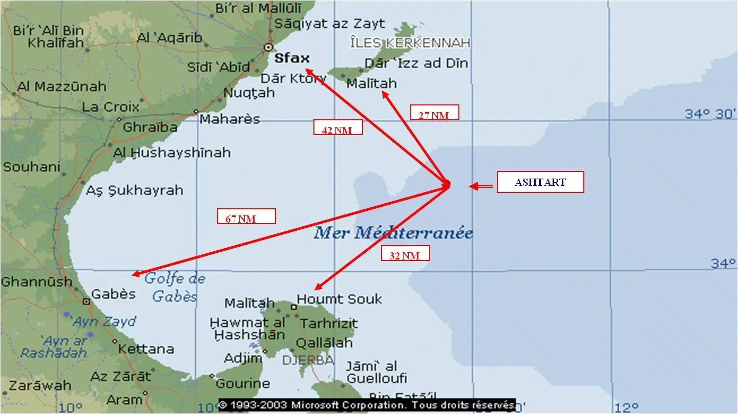
Ashtart
The ASHTART offshore site is located at points 34 ° 22'N, 11 ° 53 'E in the Gulf of Gabès in Tunisia.
The water depth is approximately 66 meters LAT.
It consists of 5 platforms and is operated by Serept.
PORT OF LA SKHIRA
The port of Skhira is located at 34 ° 19 '05' 'N; 10 ° 08 '40' 'E (Tunisia) about 350 km from the capital Tunis. It has extensive storage infrastructure for crude oil and refined petroleum products, as well as loading and unloading pipelines.
Infrastructure
- Its port infrastructure is made up of 3 workstations in Ducs-d'Albe:
- 1 station for phosphoric acid 150 ml long and 8.7 m deep
- 2 oil stations 300 ml long and 15 m deep, they can accommodate oil tankers of 120,000 tonnes.
PORT OF GABES
The port of Gabès, whose activity is characterized by an essentially industrial vocation, handles the transit of chemicals on behalf of neighboring factories located in Gabès. This bulk traffic mainly consists of sulfur and ammonia for import and phosphoric acid and phosphate fertilizers for export.
Geographical location :
Position : 33° 57 ‘N – 10° 04 ‘E
Infrastructure
Basins: The port's water body (80 ha) in 2 basins
- An outdoor pool of 50 ha, at -12.5 m.
- An interior basin of 30 ha, at -10.5 m.
The turning circle has a diameter of 600 meters
Berths :
- West quay stations 5, 6 and 7 with a total length equal to 600 m with a depth of - 10.50 m Hydro.
- North quay stations 3 and 4 with a total length of 340 m and a depth of -10.50 m Hydro.
- South quay stations 8, 9 and 10 with a total length of 785 m and a depth of -11.5 m Hydro.
- Easement quay 139 m long with a depth of -5.00m.
The commercial port of Gabès offers a linear quay with a total length equal to 1725 m.
Protection works
- A 2880 m long north jetty protects the port against waves from the prevailing north and north / east winds.
- A south jetty 1460 m long completes the protection against east and south / east winds.
Storage structure
- Fitted land: 25,000 m2
- Bare ground: 100,000 m2
- Store and covered hangar: 4000 m2
PORT OF ZARZIS
The port of Zarzis, located in the south-east of Tunisia, mainly handles bulk traffic (hydrocarbons, sea salt and olive oil) and general goods.
Geographical location :
Position : 33 ° 33 'N and 11 ° 07'
Infrastructure
Basins:
an interior basin constituting the fishing port, a main basin of 35 Ha and 11 m deep; the turning circle at 450 meters
Berths :
- the commercial quay made up of 4 stations and has a total length of 610 ml with an original depth of 11 m Hydro. its north-west end is equipped with a 20 m long quay return intended for Ro-Ro ships.
- An oil jetty with a total length of 185 ml and a depth of - 10 hydro.
- An easement wharf with a length of 155 ml and a depth of - 5 m hydro.
Protection works
- The port of Zarzis is protected by a 1505 ml long breakwater; rooted on the eastern jetty of the fishing port and having the same direction, shelters the harbor basin against the swell of the North to East sector.
Warehouses
- Two warehouses of 5000m² and 4000m² of surface.
As a Tunisian Shipping Agent, we operate and service from or to the ports shown on the map.
Also, and as a member of the Multiport Network we can handle the shipping of your goods from these ports to the rest of the world.